|
 |
Приветствую Вас Гость | RSS |
 |

|
 |
Приятного общения на АВИА-форуме !
теперь мы еще и на авиа-форум.рф
|

   |
 | |  |
|
|
Обзор авиасофта для навигаторов
|
|
| Y18T | Дата: Понедельник, 12.09.2011, 13:27 | Сообщение # 1 |
|
Полковник
Группа: Участники форума
Сообщений: 164
Репутация: 0
Статус: Offline
| Откроем ветку с программы:
Aviation Navigator
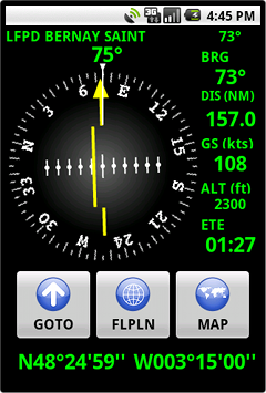 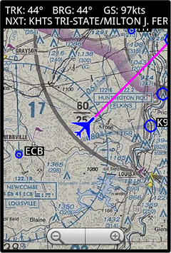
Use the GPS capabilities of android for aeronautical navigation.
* Manage waypoints (worldwide 30800 Airports, 10700 Navaids and 91000 Waypoints in our database available)
* Manage flight plans
* Use aviation maps
* Online administration (PC)
* Lifetime App updates
Сообщение отредактировал Y18T - Понедельник, 12.09.2011, 13:28 |
| |
| |
| Y18T | Дата: Понедельник, 12.09.2011, 13:31 | Сообщение # 2 |
|
Полковник
Группа: Участники форума
Сообщений: 164
Репутация: 0
Статус: Offline
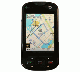
| CoPilotMap
CoPilotMap - карта для пилотов, полеты над территорией США. Указаны аэропорты, воздушные коридоры и многое другое. Есть встроенный планировщик полетов. Интерфейс специально разработан для удобства использования в самолете во время полета.Программа бесплатна, но содержит некоторые ограничения функциональности.Совместимомь: Pocket PC 2002, Windows Mobile 2003, Windows Mobile 2003 SEРазработчик: CoPilotSoft LLC
Системные требования: 10 Мб Storage + 10 Мб Program
Совместимость/адаптация: Pocket PC 2002, Windows Mobile 2003, Windows Mobile 2003 SE
Разработчик: CoPilotSoft LLC
СКАЧАТЬ
Сообщение отредактировал Y18T - Понедельник, 12.09.2011, 13:40 |
| |
| |
| Y18T | Дата: Понедельник, 12.09.2011, 13:40 | Сообщение # 3 |
|
Полковник
Группа: Участники форума
Сообщений: 164
Репутация: 0
Статус: Offline
| KeyFlight.com 3.0
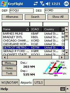
Download TAF; METAR; NOTAMS; Real Time Currency; Aviation News; Weather ...
SD Card is needed , * OS: Pocket PC 2002 , * CPU: 200MHz , * Memory: , - KeyFlight + UTILs: 120KB , - AirportsPlugin: 2.5MB (2.3MB - sql server ce) , - WeatherPlugin: 100KB , - Total: ~3MB. , + presence of Storage Card with capacity not less 128 MB
СКАЧАТЬ
Сообщение отредактировал Y18T - Понедельник, 12.09.2011, 13:43 |
| |
| |
| Y18T | Дата: Понедельник, 12.09.2011, 13:48 | Сообщение # 4 |
|
Полковник
Группа: Участники форума
Сообщений: 164
Репутация: 0
Статус: Offline
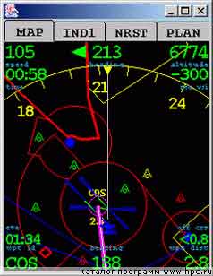
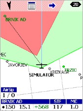
| Navgps Basic 2.5
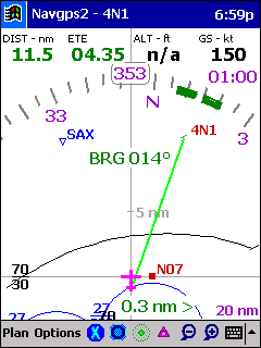
GPS navigation software for pilots
Requirements: PocketPC
Navgps is an aviation navigation software product for Windows and PocketPC platforms.
If you're a pilot, install it on a portable laptop/pocketpc, buy an inexpensive gps receiver and you'll be the source of envy at the local fbo. And given the cost, not to mention the peace on the home-front.
There were three primary goals:
Simplicity - no extraneous functions.
Increased situational awareness - HSI on top of a moving map.
Real-world flying. temporary deviation from flight-plan for IFR holds and intercepts possible.
Other features and those added to navgps2 are:
World-wide database support. if you wish, you can load one region or any combination simultaneously.
Airport communication frequencies.
Airport runway info.
Vert/Horz Runway guidance.
Airspace - part of subscribed database only.
Flight tracking.
Alarms (e.g. 'Switch Tanks!") and count-down timers (e.g. "Go around!"). gear-down warning.
Simple navaid/airport database format. if you know how to use notepad, you can create databases for your own region/waypoints.
Nearest Airport.
Simulator mode. test the application on ground w/o gps unit.
ФОРУМ ПО ПРОГРАММЕ (там-же скачать можно и про настройки почитать)
Сообщение отредактировал Y18T - Понедельник, 12.09.2011, 14:11 |
| |
| |
| Y18T | Дата: Понедельник, 12.09.2011, 14:20 | Сообщение # 5 |
|
Полковник
Группа: Участники форума
Сообщений: 164
Репутация: 0
Статус: Offline
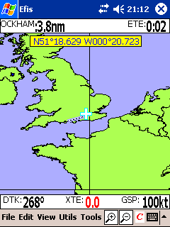
| EFISce 2003 Europe database
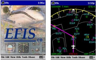
Comprehensive flight planning with navigation database. Graphical weight and balance. Allows you to scan in any MAP to use with GPS positioning
FEATURES:
Save/recall unlimited flight plans
Graphical weight and balance
Wind table
Fuel planning
Full editing of any sector
Reverse a flight plan
Quick search databases
Simulator mode
Connect to GPS for real-time navigation
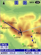
EFIS or HSI vector moving MAP displays
Scan in any MAP and use as a moving bitmap
Main screen
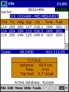
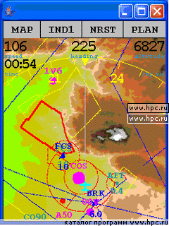
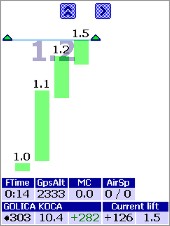
The main screen view shows the active flight plan, the sector display scrolls to display any leg. Highlight a sector to display additional information.
The flight plan totals for distance time and fuel are constantly updated as sectors are added/edited or deleted.
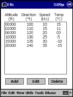
A wind table makes planning easy. As you add sectors to the plan the appropriate wind for the planned level is selected or interpolated as required.
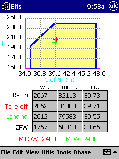
Weight and balance data is supplied for many popular types of aircraft. This can easily be added to or edited to suit your own aircraft.
There is no practical limit to the number of stations you can add.
The fuel weight and fuel burn for the planned flight are automatically calculated and converted to the right units for the aircraft type.
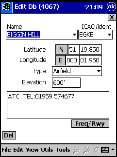
All records can easily be edited/deleted or new records added.
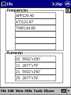 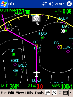
The real power of the application is demonstrated by the real-time displays driven by GPS input.
Here the EFIS view shows planned track, heading display, airfields and navaids, controlled airspace and data displays.
Продолжение следует...
Сообщение отредактировал Y18T - Понедельник, 12.09.2011, 14:37 |
| |
| |
| Y18T | Дата: Понедельник, 12.09.2011, 14:38 | Сообщение # 6 |
|
Полковник
Группа: Участники форума
Сообщений: 164
Репутация: 0
Статус: Offline
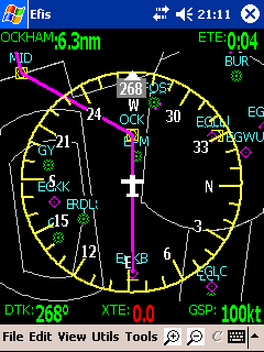
| Here the HSI view shows all the points of the compass.
All the views display in real-time when the palmtop is connected to a GPS via the serial port, Compact Flash GPS card or via bluetooth.
To visually check your plan before take-off, select simulator mode which will run the entire planned flight as if you are actually flying it.
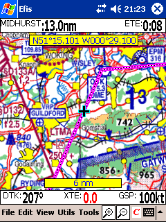
You can scan in any map of your own and calibrate it in a few seconds... now your planned flight will be displayed on your moving bitmap.
Use the zoom function to display maps of varying resolutions.
As you move to different locations the appropriate pre-scanned maps are loaded and displayed as required.
Public domain low resolution maps of the world, USA and Europe are supplied with the application.
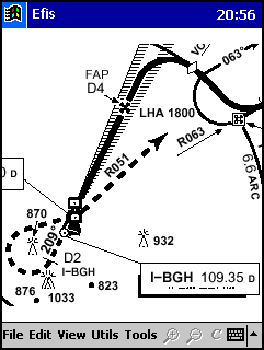
Approach plates may also be scanned in and used as a moving-map
Сайт производителя тут
СКАЧАТЬ ТРИАЛ

Сообщение отредактировал Y18T - Понедельник, 12.09.2011, 14:46 |
| |
| |
| Y18T | Дата: Понедельник, 12.09.2011, 15:06 | Сообщение # 7 |
|
Полковник
Группа: Участники форума
Сообщений: 164
Репутация: 0
Статус: Offline
| PocketFMS is a Flight Planner & GPS Moving Map software package

1. Flight Planning. Plan conveniently sitting at your own desk, with your own PC - or, with PocketFMS installed on a memory stick, any PC you have access to. Just select the departure and destination aerodromes and PocketFMS plots the route for you, considering your aircraft's performance, weather, compulsory reporting points and all. You can adjust the route via drag and drop and have PocketFMS avoid airspace classes and -types, terrain and low cloud bases. All vitals will be recomputed after each adjustment you make. Printing the mandatory paperwork (ATC flight plans, NavLogs, Weight & Balance reports, etc.) is just a few clicks away! Your flights can be pre- and postviewed using Google Earth.
2. Flight Execution. A few clicks suffice to transfer all you need to your Mobile Device. Just grab your GPS-enabled PDA, laptop, UMPC or Tablet PC and go fly! You'll constantly be aware of where you are, where you're heading, what weather and airspace you will encounter, whom to talk to and when you'll arrive. Divert with just a few keystrokes. With the proper hardware, PocketFMS can even give you graphical traffic information (TCAS). You will notice a huge drop in your cockpit workload!
3. Flight Review. PocketFMS constantly records your covered track, and reviewing it is possible within PocketFMS itself as well as via Google Earth. You can now prove you didn't incurse that airspace, show your pax exactly where you have taken them or monitor your student's solo trips! A simple yet complete logbook file records the times and locations of your take-offs and landings automatically.
Сайт производителя тут там же можно скачать прогу.

Сообщение отредактировал Y18T - Понедельник, 12.09.2011, 15:10 |
| |
| |
| Y18T | Дата: Четверг, 15.09.2011, 13:25 | Сообщение # 8 |
|
Полковник
Группа: Участники форума
Сообщений: 164
Репутация: 0
Статус: Offline
| flyWithCE - для планеристов
Overview
flyWithCE is software for Pocket PCs created by Uroš Podlogar in Slovenia.
Navigator
Navigate over waypoints, on task and around reserved airspace. Program supports standard NMEA GPS receivers, several glider instruments and the LX Navigation LX1600 instrument.
New Features
The new features found in the latest version of Navigator are available here: http://www.flywithce.com
Product Details and Manuals
Navigator Details: http://www.flywithce.com
Скачать программу тут там же есть Logbook, Flight Recorder и пр.
Инструкция пользователя тут
Сообщение отредактировал Y18T - Четверг, 15.09.2011, 13:53 |
| |
| |
| Y18T | Дата: Четверг, 15.09.2011, 14:03 | Сообщение # 9 |
|
Полковник
Группа: Участники форума
Сообщений: 164
Репутация: 0
Статус: Offline
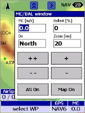
| Glide Navigator II
Так-же софт для планеристов для PDA и навигаторов
Страничка разработчика тут
Ознакомиться с описанием проги можно тут
...и загрузить ее можно отсюда
Сообщение отредактировал Y18T - Четверг, 15.09.2011, 14:05 |
| |
| |
| Y18T | Дата: Четверг, 15.09.2011, 14:08 | Сообщение # 10 |
|
Полковник
Группа: Участники форума
Сообщений: 164
Репутация: 0
Статус: Offline
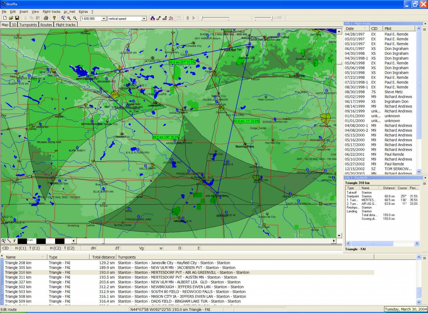
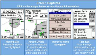
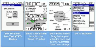
| StrePla and pocket*StrePla
Software for Cross-Country Soaring Flight Planning, Execution, and Analysis
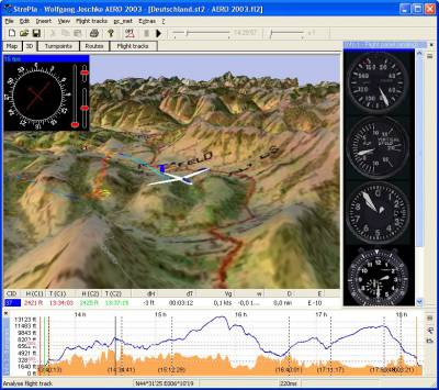
Overview
StrePla and pocket*StrePla are extremely powerful software programs for soaring pilots. StrePla for the PC can be used for pre-flight route planning and post flight analysis and replay. pocket*StrePla for the Pocket PC is for use in flight and includes detailed moving maps, final glide information, and real-time task optimization.

See the overview of unique features below or go to StrePla or pocket*StrePla pages for complete details. The Maps page gives a detailed overview of the wide variety of digital maps available in StrePla and pocket*StrePla. The Tips & FAQs page includes system requirements, start-up tips and answers to frequently asked questions.

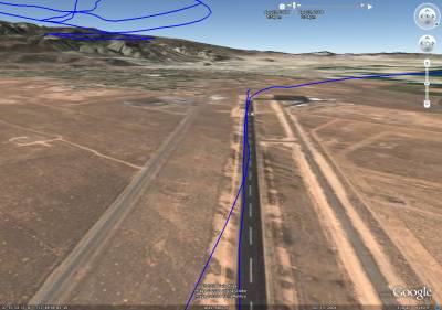
New in Version 5.1 - Google Earth View Within StrePla
Version 5.1 features a very cool new view. A Google Earth view is opened within StrePla. It is very interesting flying through your flights over the extremely detailed maps available in Google Earth. You can't view the glider from outside the cockpit, but it is extremely cool to be able to see the runway, airport buildings and other details. It really "takes you back" and makes re-living the flight a 3D reality.
И т.д и т.п. подробнее тут
Скачать отсюда
Сообщение отредактировал Y18T - Четверг, 15.09.2011, 14:11 |
| |
| |
| Y18T | Дата: Четверг, 15.09.2011, 14:18 | Сообщение # 11 |
|
Полковник
Группа: Участники форума
Сообщений: 164
Репутация: 0
Статус: Offline
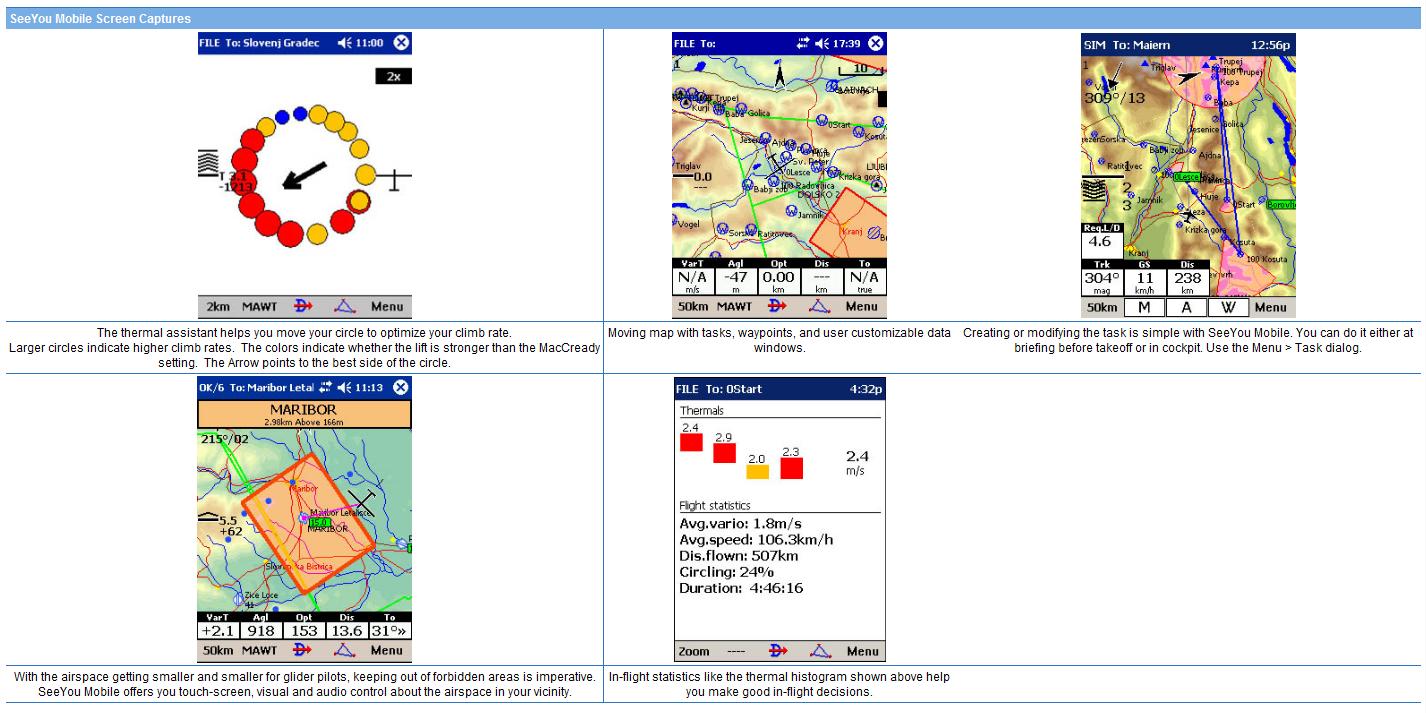
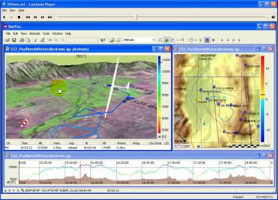
| SeeYou
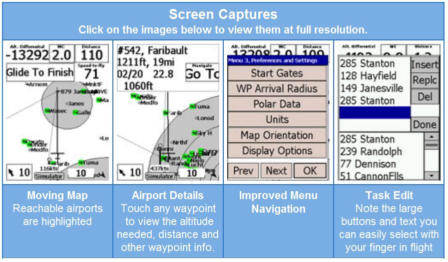
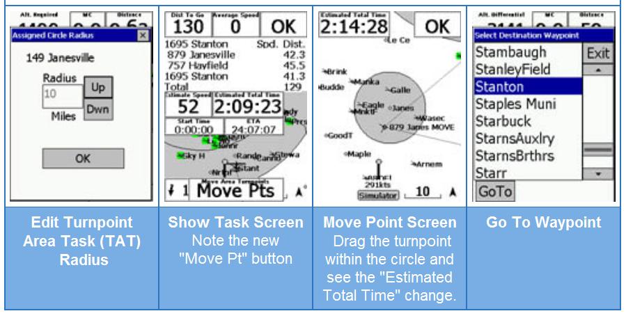
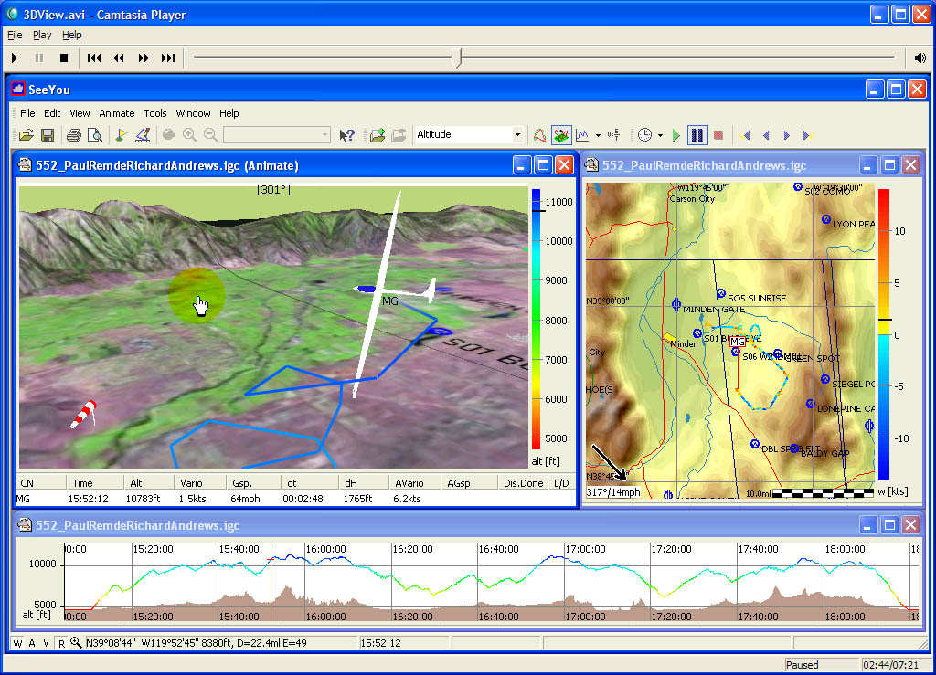
SeeYou is a flight planning and analysis tool for glider pilots. It is designed for both desktop and notebook PCs
Its functions before the flight allow you to plan tasks, manage waypoint lists and upload all that to the Pocket PC device. After the flight, it allows you to download flights from GPS devices, see your flight on maps, explore its details through Statistics and relive it in 3D view.
Подробнее тут
Скачать отсюда

|
| |
| |
| Y18T | Дата: Четверг, 15.09.2011, 14:45 | Сообщение # 12 |
|
Полковник
Группа: Участники форума
Сообщений: 164
Репутация: 0
Статус: Offline
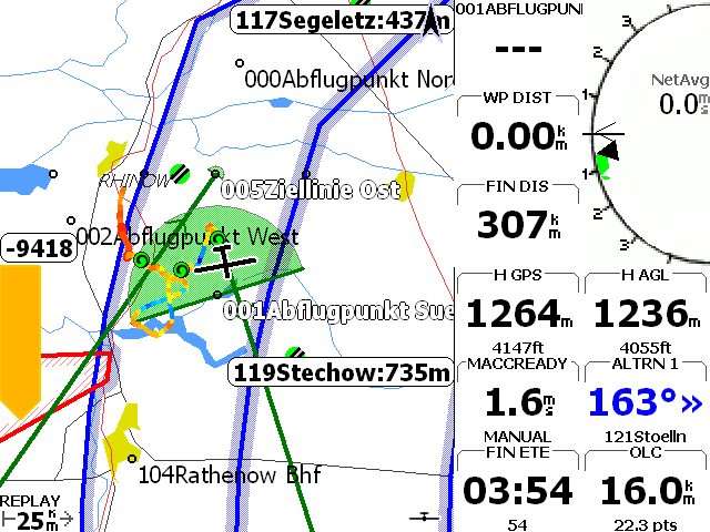
| 
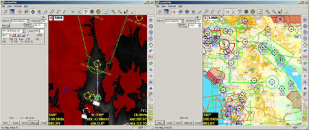
XCSoar is a tactical glide computer originally developed for the Pocket PC platform. In 2005, the originally commercial software was given to the open-source community for further development and has constantly been improved since. It is now a multi-platform application that currently runs on Windows, Windows Mobile, Unix and even Android devices.
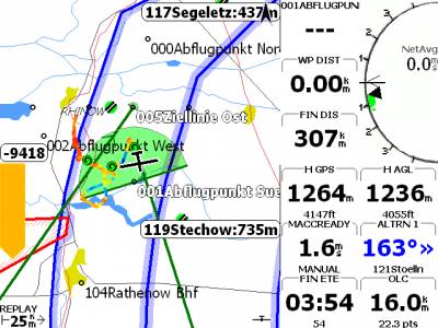
Today XCSoar has almost everything you would need as a glider pilot… and more! Due to our many active users, we are always getting new ideas of features, that one might want to have. If you feel that something is missing or you think you have found a bug, please do not hesitate and follow the guide here to write a feature request or bug report.
Мануал тут
Страница разработчиков тут
Скачать от тут
Сообщение отредактировал Y18T - Четверг, 15.09.2011, 14:45 |
| |
| |
| |
 | |  |
|
|
|
| Пятница, 26.04.2024, 02:36 |
| Меню сайта |
|
|
 |
| Форма входа |
|
|
|
| Мини-чат |
|
|
|
| Ссылки |
|
|
| Наш опрос |
|
|
|